
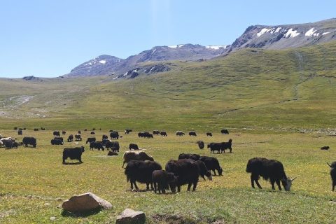
I go up to Son-Kul four or five times a year, for work and for rest, mostly in summer. The three main roads up go over the Moldo-Ashuu and Kalmak-Ashuu passes, or up the Teskey-Torpok switchbacks known as the 33 Popugaya (the thirty-three parrots). Whichever road we take, it ends on one of the best-known jailoos in the country, and the one where twenty-five years of satellite pictures show the clearest change.
When we mapped farm technology in Kyrgyzstan in 2022, with the Leader NGO, the strongest pasture tool we found was CAMP Alatoo’s Pasture Monitoring app. It was built for pasture committees and forestry units to follow grazing through the seasons, in Kyrgyz, Russian and English, and the design was sound. Few people kept using it. It had fewer than a hundred installs. Most of the herders and farmers it was made for were not used to working with apps, digital skills were low, and the habit of reading data to plan a grazing season was rarer still.
Satellite data in the Ministry of Agriculture
The second observation came in late 2024, in our work for FAO’s Digital Villages project. That work took us across the country, region by region, to talk with individual farmers, farming companies and village communities about what troubled them and what they wanted from digital services. The Ministry of Agriculture was planning to offer some of its services online through an app, yet the ministry itself had little access to geospatial data. One of its own subdivisions, Kyrgyzgiprozem, did hold satellite data, NDVI greenness among it, and used it in its own work. It did not pass that data to the ministry or to anyone else. At one of our roundtables a representative of Kyrgyzgiprozem said it plainly. The data is used for internal purposes and is not shared.
Then, in 2025, the Ministry of Agriculture set up a state enterprise, Kyrgyz Satellite, to put an Earth-observation satellite into orbit for pastures, farming and other uses. That surprised me. The free archives have been photographing the country for decades. NASA’s MODIS satellites have passed over every jailoo every few days since 2000, Landsat goes back to 1985, and Europe’s Sentinel-2 has added pictures at 10 metres since 2017. By my reckoning the ministries have used not even one per cent of what those archives already hold on pastures and crops, and they have had few people with the skills to use more. The country was preparing to build its own satellite before reading the pictures it already gets for free.
Data held inside one agency, and a new satellite planned before the open archive is in use, are familiar in many post-Soviet administrations. Here they meet a practical question that every herding family answers each spring, which is when to move the animals up.
So we started with the archive. At KG Labs we have spent the past years applying free satellite archives, cloud computing, climate grids and AI models to Kyrgyzstan’s glaciers, rivers and forests. This autumn we turned the same tools on the pastures, starting with seven well-known jailoos, one in each region. Son-Kul in Naryn, Suusamyr in Chuy, Karkyra in Issyk-Kul, Alay in Osh, Chychkan in Jalal-Abad, Besh-Tash in Talas, and Mashalan at Kyzyl-Bulak in Batken, on the Kyrgyz–Uzbek border.
Seven jailoos in the satellite record
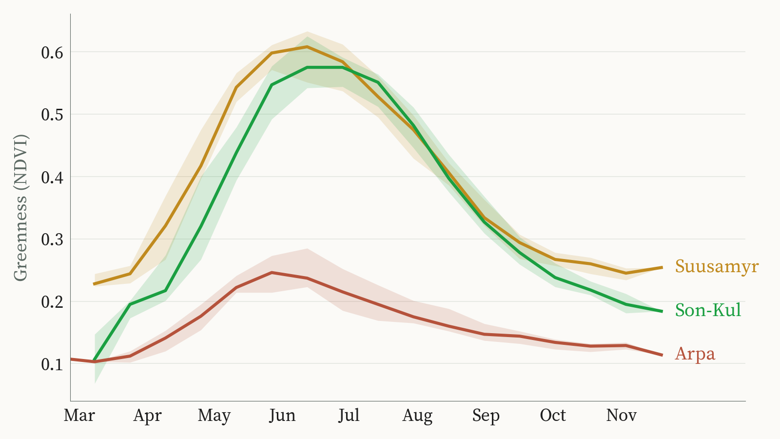
Every sixteen days the MODIS record gives each jailoo a greenness score, at a resolution of 250 metres. Over a season the score rises in spring, peaks, and falls away as the grass dries, and the curve shows when the jailoo wakes, when it is at its best and when it turns.
Laid over 25 summers, the curves give each jailoo its own calendar. The weeks of good grazing run from the day the grass turns green to the day it starts to yellow. On Karkyra and Chychkan that is about 116 days. On Son-Kul and Alay, the two highest, it is about 104.
| Jailoo (region) | Height | Share under grass | Good grazing for horses | Greenest weeks | Summer air, 1951–1980 → 1996–2025 |
|---|---|---|---|---|---|
| Son-Kul (Naryn) | 3,060 m | 78 % | 24 May – 4 Sep (~104 days) | 18 Jun – 29 Jul | 9.6 → 10.0 °C |
| Alay (Osh) | 2,850 m | 67 % | 21 May – 1 Sep (~104 days) | 12 Jun – 18 Jul | 10.0 → 10.7 °C |
| Besh-Tash (Talas) | 2,680 m | 63 % | 11 May – 28 Aug (~109 days) | 9 Jun – 14 Jul | 7.6 → 8.2 °C |
| Mashalan (Batken) | 2,590 m | 65 % | 2 May – 21 Aug (~112 days) | 25 May – 8 Jul | 11.1 → 11.6 °C |
| Karkyra (Issyk-Kul) | 2,310 m | 80 % | 8 May – 1 Sep (~116 days) | 26 May – 11 Jul | 10.8 → 11.6 °C |
| Chychkan (Jalal-Abad) | 2,170 m | 76 % | 4 May – 28 Aug (~116 days) | 24 May – 6 Jul | 12.5 → 13.0 °C |
| Suusamyr (Chuy) | 2,060 m | 81 % | 11 May – 31 Aug (~112 days) | 6 Jun – 23 Jul | 14.0 → 14.7 °C |
Typical year from MODIS greenness, 2001–2025. Good grazing runs from green-up, the day the grass passes halfway from its winter colour to that year’s peak, to the start of yellowing. Greenest weeks are the top of the season’s curve. Summer air is the June–August average from the ERA5-Land climate grid. Share under grass is of each jailoo’s mapped area. Mashalan figures are for its grassiest valley, below Mashal-Ang lake (2,588 m). Source: KG Labs pasture analysis, October 2026.
Grass covers between 63 and 81 per cent of each jailoo. On Alay, almost a third is stone and bare ground. On Son-Kul, 7 per cent is the lake. On Mashalan and Karkyra, a sixth or more is forest and shrub.
The greenest weeks are the ones that matter for kymys, because the milk follows what the mares graze. On Chychkan they come early, from late May to early July. On Son-Kul they come last, from mid-June to 29 July, ending more than three weeks after Chychkan’s.
Son-Kul turns green two weeks earlier
Son-Kul is where the record shows the clearest change. In 2001–2010 the grass on its south shore turned green around 26 May. Since 2016 it has turned green around 12 May, two weeks earlier. Across the 25 springs that works out at about nine days per decade.
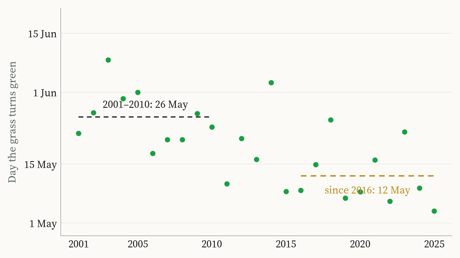
Summer greenness has not changed. The July–August greenness on Son-Kul, Suusamyr and Arpa moves up and down from year to year with no trend over 25 summers. Son-Kul’s season starts sooner and reaches the same height. On Suusamyr and Arpa even the start has not clearly moved.
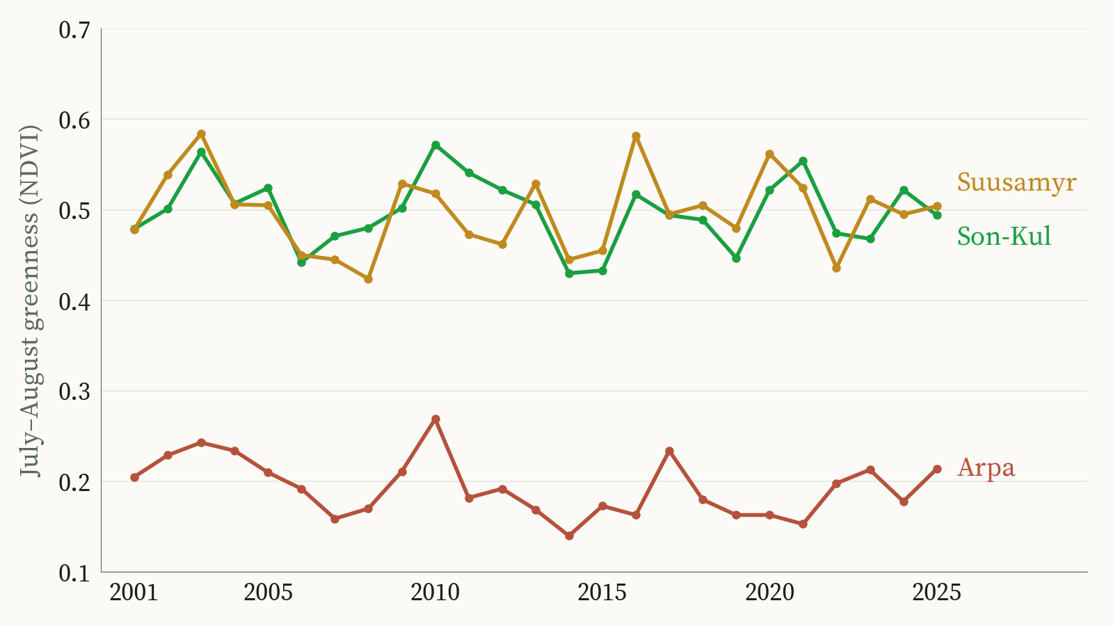
An earlier start with the same summer means the young spring grass arrives sooner. A herd that goes up on the old date may meet older grass. Whether that changes how the animals put on weight is a question for field data.
Air temperature records show the same shift. In At-Bashy, the grass-growing season measured from air temperature is now 4 days longer than in 1951–1980, and on Son-Kul about a week longer. The climate models carry that forward to about 12 more days in the Naryn valleys by 2040.
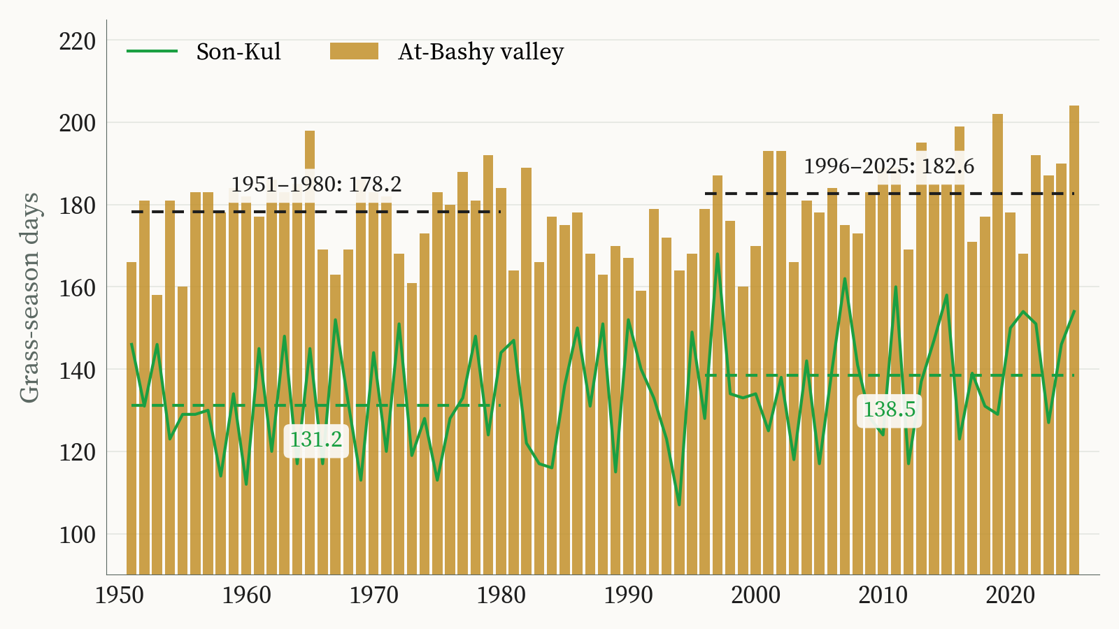
Across all seven jailoos, summers have warmed by between 0.4 and 0.8 °C since 1951–1980. The first autumn frost has not moved. On Son-Kul it still comes around 27 September, on Besh-Tash around 9 September, on Chychkan around 3 October, as it did seventy-five years ago. So the change shows at the start of the season, in spring.
Summer 2026
This summer was among the four warmest in 76 years on six of the seven jailoos. On Karkyra and Suusamyr it was the warmest on record, about 2 °C above usual.
| Jailoo | Summer air 2026 | Against usual | Warmth, rank of 76 | July–August green, rank of 26 | Grass turned green |
|---|---|---|---|---|---|
| Son-Kul | 11.0 °C | +1.2 °C | 2 | 1 | 21 May, about usual |
| Besh-Tash | 11.4 °C | +1.2 °C | 2 | 1 | 6 May, 5 days early |
| Alay | 12.9 °C | +1.9 °C | 3 | 5 | 14 May, 7 days early |
| Chychkan | 14.6 °C | +1.3 °C | 4 | 5 | 25 April, 9 days early |
| Suusamyr | 17.2 °C | +1.9 °C | 1 | 5 | 18 May, 7 days late |
| Karkyra | 13.9 °C | +2.1 °C | 1 | 12 | — |
| Mashalan | 14.1 °C | +1.0 °C | 9 | 14 | 27 April, 5 days early |
2026 against each jailoo’s own record: air temperature 1951–2026 from ERA5-Land, greenness 2001–2026 from MODIS. 2026 temperatures come from a reanalysis that is still being finalised and may change. Source: KG Labs pasture analysis, October 2026.
The heat affected the seven jailoos differently. Son-Kul and Besh-Tash, the two coldest jailoos in the set, had their greenest July and August in 26 years of pictures. Karkyra had its warmest summer in 76 years and came twelfth for green. On the high, cool pastures a hot summer seems to help the grass. Lower down the help is less clear. Seven places are too few to call that a rule, and it is the pattern we most want to test on more jailoos.
The autumn frost was just as uneven. On Son-Kul it came on 14 October, more than two weeks late. On Suusamyr there had been no frost at all by 20 October. On Alay and Mashalan it came on 6 September, earlier than usual, after one of the warmest summers either has had.
Seasonal averages also hide single bad days. In June this year heavy snow fell on Kyrgyz jailoos when nobody expected it, and farmers and herders were worried for their animals. It has happened before. On 31 May 2025 heavy snow in Naryn region cut off a shepherd and his livestock on the Arpa jailoo, one of the three pastures in the film above. The Ministry of Emergency Situations had issued a storm warning. Its rescuers went up with five local residents and staff from At-Bashy district and the border service, and the head of the local aiyl okmotu organised two trucks of hay for the stranded animals. Six people on their way to the Ak-Sai pasture had to be helped, and 15 to 20 centimetres of snow blocked the Bishkek–Naryn–Torugart road near Arka. In some recent years, snow like this has cost herders livestock. A storm that lasts a few days drops out of a sixteen-day satellite record, since snow-covered dates are left out, so late snow does not show in the tables above.
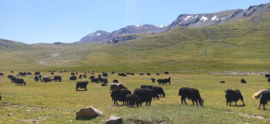
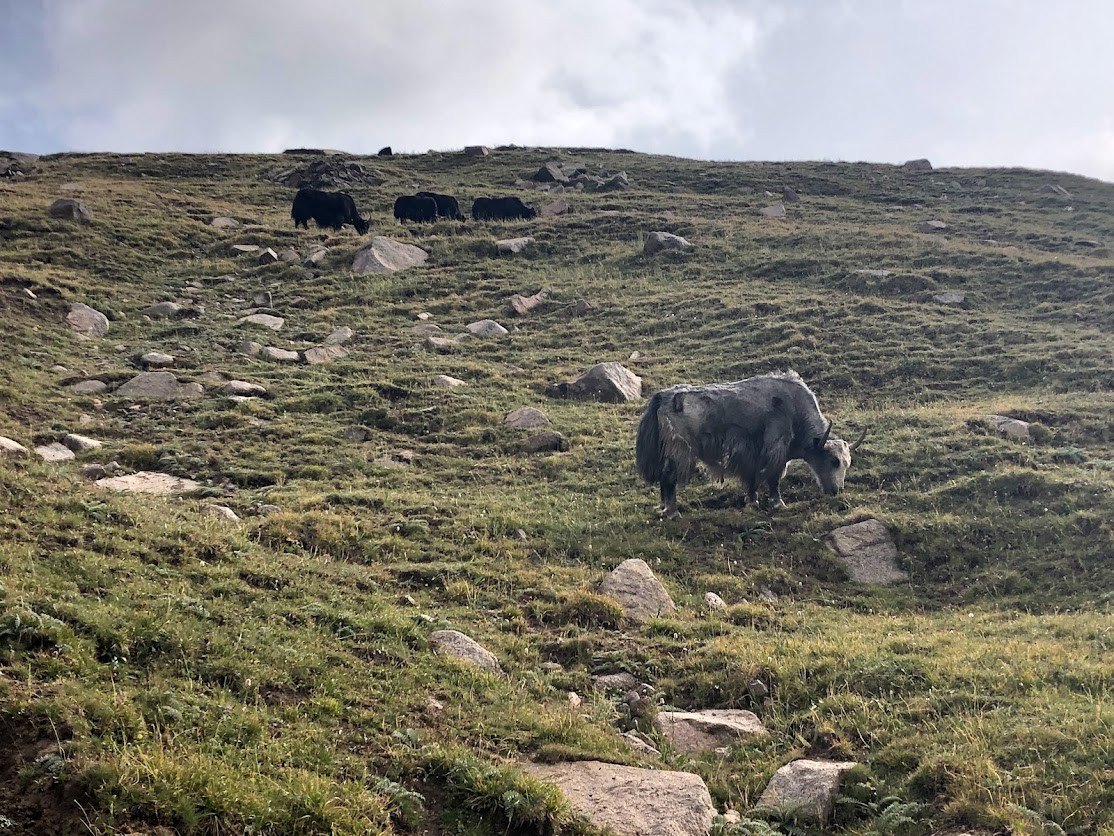
Cows, sheep and horses come up to the jailoos for the summer and go back down in autumn. Yaks live in the high country and rarely come below about 2,500 metres. When snow falls at the end of May, or a summer runs two degrees warmer than any before it, the yaks are already up there. How they come through sudden snow, and through a climate shifting around them, is the question that has stayed with me on the road to Son-Kul. The satellite record cannot answer it.
Limits of the satellite record
A satellite measures how green the grass is, and greenness alone does not tell how much grass there is. A jailoo grazed short and a jailoo left long can look equally green from space, and the only way to turn greenness into kilograms of forage per hectare is to clip and weigh grass in marked plots on the ground. No such plots have been run on these seven jailoos yet.
At 250 metres one MODIS pixel mixes grass, rock and paths. Sentinel-2 at 10 metres sharpens the picture from 2017 on, enough to show where green fades in rings around camps, wells and winter barns. Clouds and snow hide some dates, and those dates are left out of the record. Grazing pressure itself needs herd numbers and routes, which only herders and pasture committees know.
For visitors, the same weather record gives the weeks when a day on the jailoo is likely to be comfortable, with air between 15 and 28 °C, no frost at night and a clear afternoon. On Alay about seven days in ten in its best weeks are like that. On Son-Kul and Besh-Tash it is one day in three, even at the height of summer.
Films in Kyrgyz for herders
Because of what we saw in 2022, the findings go out in a different form. The seven jailoos are published as short films and picture carousels in Kyrgyz, one jailoo at a time from late October to late November, on the social channels people already use. Each one opens with the name of the jailoo, so that someone searching for their own valley finds it, and each answers three plain questions. How many days of good grass does the jailoo give the horses? When is the grass greenest for the mares and kymys? When is the best time to visit? Viewers do not need to install anything or read a chart.
Driving up to Son-Kul year after year, I have come to think the missing piece is people with the skills and the tools to use what already exists. Trained and equipped, herders and the local pasture committees could match the number of animals to what a jailoo can carry, set the date a pasture opens, and choose which slopes to rest for a season. The satellite record can already help with the timing and with finding where grass is thinning. How many animals a pasture can carry still needs the clipped plots on the ground.
For KG Labs the series is also a demonstration of what the open archive holds for anyone who manages pastures, from a herding family to a pasture committee to the ministry. The same pictures, read slope by slope at 10 metres, can show where grass thins around a camp and whether a rested pasture comes back.
Son-Kul’s earlier spring is the clearest thing the archive shows so far. Whether the herders who move up to Son-Kul each year have noticed the same two weeks is the question I want to put to them on my next trip up the Moldo-Ashuu road.
Aziz Soltobaev · KG Labs Public Foundation · Bishkek, 2 November 2026
Sources: grass greenness from NASA MODIS MOD13Q1 NDVI (250 m, 16-day composites, 2001–2026); grassland from ESA WorldCover 2021; terrain from Copernicus GLO-30; air temperature, frost dates and grass-season length from the ERA5-Land climate grid (Copernicus Climate Change Service), 1951–2026, with 2026 preliminary; projections to 2040 from 14 CMIP6 climate models; computed in Google Earth Engine by KG Labs. Son-Kul green-up trend about 9 days earlier per decade (Kendall test, p < 0.001, 25 springs); Suusamyr and Arpa show no clear shift (p > 0.2); July–August greenness shows no trend at any of the three (p > 0.1). The 2022 farm-technology mapping was carried out by KG Labs with the Leader NGO. The May 2025 snow on the Arpa jailoo is from a press release of the Ministry of Emergency Situations of the Kyrgyz Republic, 1 June 2025.
Also in: Русский